Water resource plans are a key tool for putting the Murray-Darling Basin Plan into action.
On this page:
The Murray-Darling Basin Plan aims to achieve healthy, working rivers that support productive and resilient water-dependent industries, healthy and resilient ecosystems and communities with access to sufficient and reliable water supplies. The Murray-Darling Basin Plan required all Basin states, including Victoria, to prepare water resource plans and comply with sustainable diversion limits from June 2019.
The Murray-Darling Basin contains 20 surface water and 22 groundwater water resource plan areas, as well as 6 combined surface water and groundwater water resource plan areas.
Water resource plan
A water resource plan is required for each WRP area in the Murray-Darling Basin and aim to improve consistency and transparency in water resource management.
Victoria developed 2 plans across 5 WRP areas.
For each plan, we have provided in the document breakdown:
a summary of the areas covered by the water resource plan
details on the plan’s submission, index table and stakeholder engagement
the Water Resource Plans’ Comprehensive Reports
all Parts and Appendices.
Victoria’s WRPs also contain Water Quality Management Plans as Appendices. They are summarised in Part 14 of the Wimmera-Mallee Water Resource Plan and Chapter 14 of the North and Murray Water Resource Plan, respectively.
the Wimmera-Avon, Avoca and Mallee surface water basins
the Wimmera-Mallee and Avoca groundwater catchments.
WRP submission letter and index table
Victoria submitted the proposed Wimmera-Mallee Water Resource Plan to the MDBA on 22 February 2019.
Key documents for the Wimmera-Mallee Water Resource Plan submission:
Submission letter to MDBA
Wimmera-Mallee Index Table, which includes the specific responses to each Basin Plan requirement and specifies the proposed text for accreditation by the Commonwealth Minister.
The document is separated into the following parts and appendices.
Part 1: gives an introduction of water resources in the plan area, including an introduction of the plan
Part 2: covers the WRP areas
Part 3: discusses the landscape, people and economies
Part 4: details the water resources
Part 5: gives an overview of Victoria’s water governance structure
Part 6: explains Victoria’s entitlement framework and trade
Part 7: provides an overview of Victoria’s approach to the risk assessment found in Appendix B
Part 8: provides a summary of the methods used to determine sustainable diversion limits and take, supported by further information in Appendix C
Part 9: how Victoria responds to extreme events and critical human water needs
Part 10: explains interception from commercial plantations and runoff dams
Part 11: demonstrates how Victoria meets Basin Plan requirements for Aboriginal water values and uses and explains how Traditional Owner groups were involved in the development of the plan
Part 12: explains how Victoria meets its environmental watering requirements
Part 13: explains how recreational water in Victoria is managed
Part 14: provides a summary of Victoria’s approach to the Wimmera-Mallee Water Quality Management Plan. The full water quality management plan is provided at Appendix A. See below for more information.
Part 15: outlines how measuring and monitoring is undertaken in Victoria.
Appendix D: is the consultation report that summaries the extensive public consultation, Traditional Owner engagement and stakeholder involvement throughout the development of the plan.
Additional information is available in the glossary and references of the Comprehensive Report.
Victoria’s North and Murray Water Resource Plan
Visit the Murray-Darling Basin Authority for information on:
Document breakdown of Victoria’s North and Murrary Water Resource Plan.
Sometimes referred to as the Northern Victoria Water Resource Plan, Victoria’s North and Murray Water Resource Plan covers:
the Mitta Mitta, Kiewa, Ovens, Broken, Goulburn, Campaspe and Loddon rivers connected to the Murray
floodplain wetlands of the Murray River, such as Hattah Lakes, Lindsay Island and Barmah National Park and the connected wetlands in the Loddon, Goulburn and Ovens catchments
all groundwater in the northern Victoria area
the Sunraysia and Goulburn-Murray irrigation districts
WRP submission letter and index table
Victoria’s North and Murray Water Resource Plan areas were accredited by the Minister for Resources, Water and Northern Australia on the following dates:
Northern Victoria water resource plan area (accredited 28 May 2020) see Water Act (Northern Victoria Water Resource Plan) Accreditation Decision 2020
Victorian Murray water resource plan area (accredited 10 June 2020) see Water Act (Victorian Murray Water Resource Plan) Accreditation Decision 2020
Goulburn-Murray water resource plan area (accredited 10 June 2020) see Water Act (Goulburn-Murray Water Resource Plan) Accreditation Decision 2020
Victoria’s North and Murray Water Resource Plan was submitted to the MDBA on 30 April 2019.
The MDBA advised Victoria that its assessment found that components of the WRPs needed further development. Subsequently, Victoria resubmitted Victoria’s North and Murray Water.
Submission letter to MDBA which includes the Statement of Reasons.
Victoria’s North and Murray Index Table which includes the specific responses to each Basin Plan requirement and specifies the proposed text for accreditation by the Commonwealth Minister.
For more information on how stakeholders were engaged to develop the plan see Appendix D.
The following documents form part of the formal submission package:
Chapter 1: an introduction of water resources in the plan area, including and in the introduction of the plan
Chapter 2: the areas covered by the WRP.
Chapter 3: the landscape, people and economies.
Chapter 4: details of each Basin.
Chapter 5: provides an overview of Victoria’s approach to the risk assessment found in Appendix B
Chapter 6: an overview of Victoria’s water governance structure
Chapter 7: explains Victoria’s entitlement framework and trade
Chapter 8 and Appendix F: demonstrate how Victoria meets Basin Plan requirements for Aboriginal water values and uses, and explain how Traditional Owner groups were involved in the development of the plan
Chapter 9: provides a summary of the methods used to determine sustainable diversion limits and water take, supported by further information in Appendix C
Chapter 10: explains how Victoria responds to extreme events and critical human water needs
Chapter 11: explains interception from commercial plantations and runoff dams
Chapter 12: explains how Victoria meets its environmental watering requirements and is supported by further information in Appendix E
Chapter 13: explains how recreational water in Victoria is managed
Chapter 14: provides a summary of Victoria’s approach to Victoria’s North and Murray Water Quality Plan and Appendix A provides the full Plan
Chapter 15: outlines how measuring and monitoring are undertaken in Victoria.
Appendix D: is the consultation report that summarises the extensive public consultation, Traditional Owner engagement and stakeholder involvement throughout the development of the plan.
Additional information is available in the glossary and references of the Comprehensive Report.
Water resource plan development and consultation
How did Victoria’s WRPs respond to each requirement in the Murray Darling Basin Plan?
Chapter 10 of the Basin Plan outlines the requirements for water resource plans. These include:
setting out the quantity of held environmental water and planned environmental water and incorporating the rules and management arrangements associated with delivery and use of this water
setting out how much water can be taken annually for consumptive use in a way that meets the sustainable diversion limit
ensuring that environmental watering is consistent with the Basin-wide environmental watering strategy
setting out the circumstances when trade is allowed within and between groundwater sustainable diversion limit resource units and from groundwater to surface water sustainable diversion limit resource units
outlining how water will be managed during extreme events
setting out how interception activities will be managed and monitored, including runoff dams, commercial plantations, mining activities and floodplain harvesting
a plan to manage water quality standards
outlining the risks to water resources and strategies to address these risks
identification of Traditional Owner objectives and outcomes for water resource management.
For details on how Victoria responded to each requirement in Chapter 10 of the Basin Plan see the Wimmera-Mallee Index Table and Victoria’s North and Murray Index Table.
Which groups were consulted with during development?
Victoria's water resource plans were developed in partnership with:
water corporations
catchment management authorities
environmental managers
Traditional Owners
industry bodies
local government
Basin communities.
Technical Advisory Group
A Technical Advisory Group was set up for the development of each water resource plan which included stakeholders from:
relevant rural and urban water corporations
catchment management authorities (CMAs)
the Victorian Environmental Water Holder
peak bodies including Murray Lower Darling Rivers Indigenous Nations (MLDRIN)
the Victorian Farmers Federation (VFF)
VicWater
Environment Victoria
Goulburn Valley Environment Group.
Traditional Owner contributions
Victoria worked closely with Murray Lower Darling Rivers Indigenous Nations (MLDRIN) and Traditional Owner groups identified as having an interest in water within Victoria’s water resource plan areas.
The engagement was tailored to the needs of each Traditional Owner group. Each group was given the opportunity to tell us how they wanted to be engaged with and to develop their own content for inclusion.
The contributions of 9 different Traditional Owner groups can be found in Part 11 of the Wimmera-Mallee Comprehensive Report and the contributions of 14 Traditional Owner Groups can be found in Chapter 7 of Victoria’s North and Murray Comprehensive Report.
The Traditional Owner objectives and outcomes: compilation of contributions to Victoria’s water resource plans collates information from the Traditional Owner contributions to Victoria’s water resource plans.
The assessment of current and future risks will determine how water resource plans should respond to residual risks to the availability and condition of Victoria’s water resources.
The risk assessment considered risks at a water resource plan area scale rather than a localised scale. Residual risks are those identified after existing management arrangements were applied. For more information on the risk assessments undertaken, see Appendix B in the Wimmera-Mallee Comprehensive Report and Victoria’s North and Murray Comprehensive Report.
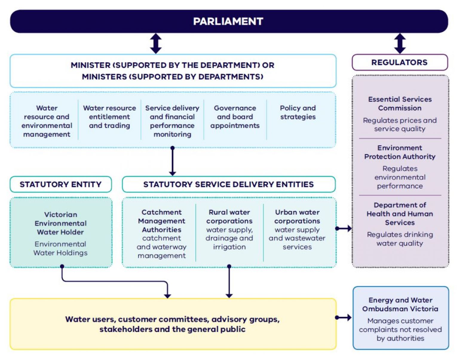
How are water resources managed?
The Minister, water corporations, catchment management authorities, the Victorian Environmental Water Holder and other regulatory bodies manage Victoria’s water resources.
Structure of the Victorian water sector
The Victorian Water Act outlines statutory rights and entitlements to take and use water in Victoria. For more information on access to take and use water see Part 6 of the Wimmera.