On this page:
Victorian Constraints Measures Program Feasibility Study
The Constraints Consultative Committee has now completed a study on the feasibility of relaxing constraints in Northern Victoria. This study provides the Victorian Government with a better understanding of the environmental and social benefits and risks, including those associated with planned inundation of private land and assets.
As part of the study, impacts on landowners, assets and the environment have been evaluated in different inundation scenarios. These have also been compared with continuing current operating arrangements to understand the key benefits and risks of constraints.
The study is the result of two years of investigation, consultation and technical work overseen by a committee of key stakeholders including landholders, Goulburn Murray Water, environmental agencies, Traditional Owners, local government and representative bodies.
Strengthened by updated modelling and contemporary technical investigations, the Feasibility Study details the benefits and risks of relaxing constraints along sections of the Goulburn and Murray Rivers and the potential implications for private landholders and local communities. The Feasibility Study is a key input to broader investigations of constraints relaxation across the Southern-Connected Basin and will help the Murray-Darling Basin Authority prepare a Constraints Implementation Roadmap which will define an appropriate way forward for considering Constraints Measures across all basin states.
The Murray-Darling Basin Authority is required to prepare a Constraints Relaxation Implementation Roadmap by 31 December 2024.
All Basin Plan states are required to agree on activities and scope across jurisdictions before proceeding further. Victoria will continue to participate in this process, ensuring issues raised in its feasibility study are considered as part of all joint strategies.
The Victorian Government will advocate that the Constraints Roadmap must clearly outline:
- Long and short terms benefits to both communities and the environment
- How risks of inundation will be managed
- A clear process for meaningful ongoing engagement with communities.
It's important to note we will not flood private land without the landholder's consent. We will not use compulsory powers to acquire land or easements, either.
Victoria will continue to engage with landholders to better understand the program’s benefits and impacts to the community if the program proceeds beyond the roadmap.
In the meantime, work will continue to get much needed water back onto high-value floodplains along the Murray River, including through the Victorian Murray Floodplain Restoration Project (VMFRP).
Supporting technical documentation
These reports capture all the work done in the development of the Feasibility Study. They will be used to help the Victorian and Australian Governments make decisions on large-scale projects like the Constraints Measures Program.
Factsheets
How has the environment changed?
River regulation and climate change have interrupted many of the natural river and wetland processes. Native plants and animals depend on these processes to survive and thrive.
Water for the environment is released into some of these rivers and wetlands to improve their health. There are, however, physical and operational barriers that prevent some low-lying floodplains from being watered, and these barriers are known as constraints.
Better outcomes for the environment
We aim to enhance environmental and cultural outcomes, by looking at how already-available water for the environment could be delivered to these areas.
We are exploring opportunities to enhance higher river flows to re-establish natural river and wetland processes that support healthy fish, bird and vegetation populations. Under predicted climate change scenarios, these systems are less likely to receive enough water in the future.
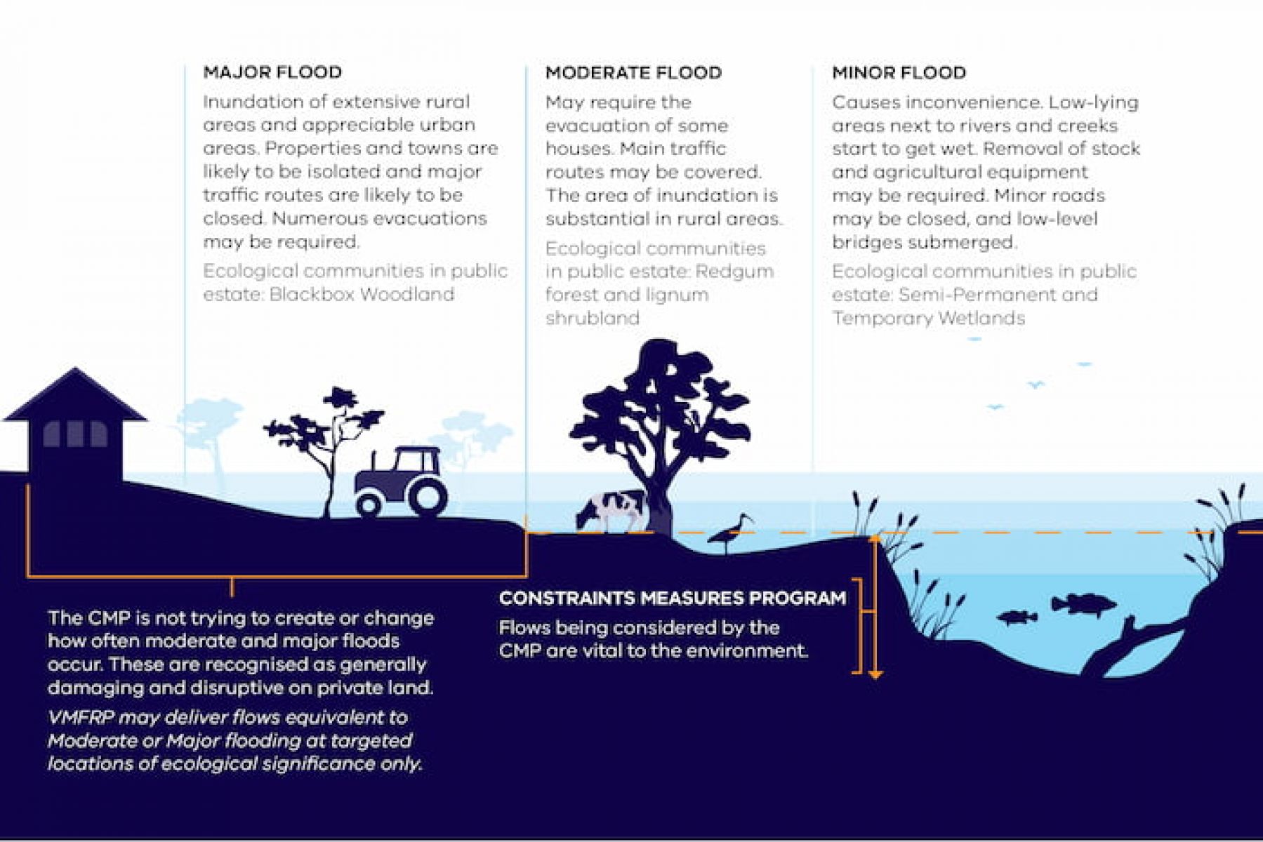
Victoria is investigating restoring minor flooding in the Murray and Goulburn rivers. Our investigations are focused at or below the minor flood level, as moderate and major floods would require vast amounts of water. Major flooding would also impact industry, agricultural production, infrastructure and urban centres.
However, restoring flows to below minor flood levels may impact private land, agricultural production, stock, private access roads and other public infrastructure such as roads, bridges and culverts.
The Victorian Constraints Measures Program
The Constraints Measures Program is exploring how enhanced natural river flows could be delivered, ‘piggybacking’ on natural flows, while managing risks and impacts to public and private land, infrastructure, stock, crops and people.
The Constraints Measures Program is part of a wider initiative that makes the best use of available water for the environment and delivers water to where it’s needed.
Another great example is the Victorian Murray Floodplain Restoration Project. These complementary projects help reduce the need for further water recovery by delivering water to high value areas the Constraints Measures Program cannot reach or sustain to meet ecological watering needs.
How does the Victorian Constraints Measures Program interact with the Victorian Murray Floodplain Restoration Project?
The Constraints Feasibility Study has explored flows to deliver environmental water equivalent to minor flood levels. This could water low-level parts of the floodplain, flood runners and low-lying wetlands (see Figure 1). This will still leave many high value areas of the floodplain without the water they need to survive.
The VFMRP will complement the CMP by ensuring we can deliver the equivalent of medium and major environmental events at these sites to help restore some of the Victorian Murray’s most valuable floodplains. VMFRP infrastructure such as flow regulators, channels, culverts and containment banks, will enable Victoria’s waterway managers to target inundation events with the frequency, timing and duration needed by floodplain plants and animals.
Both programs complement each other and are central to delivering environmental and cultural benefits to local communities.
The combination of environmental water and infrastructure is not a new concept. It was recognised many years ago in 2003 when Basin Governments committed to The Living Murray, which included a package of water returns for the environment and associated infrastructure to deliver the recovered water to priority sites along the Murray. The Living Murray demonstrates the effectiveness of combining environmental water, infrastructure, and river operations to achieve good outcomes. Further information on The living Murray can be found at: The Living Murray | Murray–Darling Basin Authority (mdba.gov.au)
Figure 1 – Schematic of what parts of the floodplain the CMP will enable environmental water to be delivered to.
Links to Basin Plan
The Victorian Constraints Measures Program targets the larger, landscape-scale environmental objectives of the Murray-Darling Basin Plan. Constraints relaxation aims to deliver water from storages on the back of higher, natural flows, improving connectivity between river reaches and the surrounding low-lying floodplains in the Southern Connected Basin.
In December 2023, the Commonwealth Government made changes to the Basin Plan through legislation. It also required the Murray-Darling Basin Authority to prepare a Constraints Roadmap by December 2024, in consultation with Basin states.
The Water Amendment (Restoring Our Rivers) Bill 2023 provides additional time until 31 December 2026 for Basin state governments to work with communities to design projects on constraints measures.
What does this mean for Victoria?
There are 6 constraints projects across the Southern Connected Basin. These are:
- Hume to Yarrawonga
- Yarrawonga to Wakool Junction
- Goulburn
- Murrumbidgee
- Lower Darling
- Lower Murray (South Australia).
Victoria is the sole proponent for the Goulburn River project, a joint proponent with New South Wales for the Hume to Yarrawonga project and a contributor towards the Yarrawonga to Wakool Junction project which potentially impacts Victorian floodplain.
Cultural outcomes
Traditional Owners have an enduring connection to Country and water resource management. As part of the consultative process, DEECA has engaged with Traditional Owners with interests in relaxing constraints – and they have shared their perspectives with the engagement team in seven on-Country workshops. This included Traditional Owner groups across the project area and downstream to the Victoria/South Australia border.
DEECA will continue to partner with Traditional Owners, recognising their central role for healing Country and identifying areas of cultural value that can be watered by relaxing constraints.
Consultative Committee
To support investigations into constraints relaxation, Victoria worked with an independent Consultative Committee to develop a robust feasibility study.
This involved:
- filling data gaps
- updating modelling tools
- assessing the cultural, recreational and environmental benefits and impacts of changed flows
- considering policy aspects such as how landowners can be compensated for any impacts
- looking at river operation requirements
- outlining a range of options to introduce more natural river flows including periodic flows generally up to the minor flood levels.
Independently chaired by the Hon. Patrick McNamara, the Committee was a forum for members to provide comments and input on the design and feasibility of the program.
The Consultative Committee comprised of members from:
- Registered Aboriginal Parties
- local landholders and irrigators
- community members
- river operators
- Council representation
- Catchment Management Authorities
- land managers and agencies
- representative bodies and impacted agencies.
DEECA engaged with agencies to identify community members who had experience and knowledge across water-based issues.
Your questions answered
Program information and related resources
Business cases
Other resources
Environmental videos
Page last updated: 13/11/25