On this page:
During October 2022 the Campaspe River experienced major flooding, with flood waters causing significant damage to farms, townships, roads, water supply infrastructure and communities.
Following these floods, the Department of Energy, Environment and Climate Action (DEECA) engaged Hydrology and Risk Consulting (HARC) to undertake a technical assessment of Lake Eppalock. The assessment was to determine if changing the operating and infrastructure arrangements could improve protection for downstream communities from future flooding and the associated financial and non-financial implications of such changes.
The assessment looks at 5 options in detail that could be put in place to improve protection for downstream communities from future flooding.
The outputs from this assessment will provide valuable input to the review of the Rochester Flood Management Plan being undertaken by Campaspe Shire with support from North Central Catchment Management Authority (NCCMA).
A working group was established to support the delivery of the assessment. The working group consists of DEECA, Goulburn-Murray Water, Coliban Water, Central Highlands Water, the Victorian Environmental Water Holder, the NCCMA, Bendigo City Council and Campaspe Shire Council.
What options have been looked at?
The technical assessment investigated 5 options as selected and agreed by the working group:
The first 3 options involve lowering the target storage or Full Supply Level (FSL) at Lake Eppalock. These options would therefore reduce the volume of water stored in the Campaspe system for entitlement holders.
The other 2 options would maintain the existing FSL at Lake Eppalock but hold more water behind the dam wall during floods. These options would therefore increase the number of recreational and commercial tourism sites around Lake Eppalock that are inundated during floods.
Option 1: Reduction of target storage levels, for example, where possible holding the lake at a maximum volume of 50%, 70%, 90% of FSL all year round), using existing infrastructure
Option 2: Reduction of target storage levels, for example, where possible holding the lake at a maximum volume of 50%, 70%, 90% of FSL all year round), and increasing the outlet capacity (from 1,600 to 5,000 ML/day)
Option 3: Reduction of Full Supply Level (to 70% of current FSL) using a passive spillway slot
Option 4: Maintenance of Full Supply Level, and the addition of spillway gates
Option 5: Maintenance of Full Supply Level, combined with the changes to the spillways (installation of piano keys) and the reconfiguration of embankments to enable more water to be stored during floods
The intent of the assessment
The technical assessment provides important information on how the 5 options compare and rank against each other, and an initial assessment of the flood mitigation benefits and capital cost of each option. The capital costs for the works were estimated to a AACE Class 5 level, which are typically within -50% to +100% of the true cost.
It also provides a preliminary assessment on how these options could impact other users within the system such as existing entitlement holders, the environment, Traditional Owners, recreational users, and upstream landholders.
The assessment does not consider the ongoing operational and maintenance cost, the ongoing economic and social consequences of reducing the volume of entitlement in the Campaspe system, or the social and economic impacts of holding the Lake Eppalock water level below FSL.
The assessment considers the increase in approximate flood damages upstream and the approximate reduction in flood damages downstream. However, does not consider the ongoing social impact and/or benefit of these changes to those communities.
Current policy and legislative requirements
An overview on current policy and legislative requirements that need to be considered in the prioritisation of options at Lake Eppalock is provided within the Explanatory note (see below).
This is not an exhaustive list; there may be other policy and legislative requirements not listed that may need to be considered.
Lake Eppalock Technical Assessment Reports
Lake Eppalock Technical Assessment webinar
A live online public webinar was held on the evening of Monday 18 December 2023.
The Lake Eppalock Technical Assessment webinar explains how the five options investigated could reduce the impacts of future flooding on downstream communities and the impacts and trade-offs of the five options on other users in the Campaspe system.
Community consultation
Between March and April 2024 DEECA sought feedback via a survey on Engage Victoria to better understand the benefits and negative impacts of the options investigated as part of the Lake Eppalock Technical Assessment.
This feedback has been captured in the What We Heard report. The Lake Eppalock Technical Assessment Report and public consultation feedback has been provided to Campaspe Shire Council for consideration in the review of the Rochester Flood Management Plan.
The review of the Rochester Flood Management, being led by council with technical support from North Central CMA, will include the benchmarking of all flood mitigation options for Rochester such as levees, house raising and changes to the operations/infrastructure at Lake Eppalock. The review is underway and will include significant community and stakeholder engagement including a robust governance and management framework and a community reference group.
Deliverables and timeline
-
November 2023
Lake Eppalock Technical Assessment Report
Report published on DEECA website and stakeholders and members of the community informed of the findings of the Lake Eppalock Technical Assessment
-
March – April 2024
Technical assessment feedback opportunity
Consult and seek feedback from the community, focusing on other impacts and benefits that need to be considered across the five options via the Engage Victoria platform.
-
October 2024
Community Engagement Findings Report
Report published on DEECA website to inform and report back on ‘what we heard’ through the engagement
-
2024 – 2025
Rochester Flood Management Plan
Rochester Flood Management Plan – benchmarking of flood mitigation options – including community consultation – led by Campaspe Council, with support from NCCMA. DEECA will work with Campaspe Council and NCCMA to determine if any other analysis is needed on the Lake Eppalock options to help inform the benchmarking of flood mitigation options.
-
2025/2026 – beyond
Potential preferred flood mitigation option(s) for Rochester
Post the Rochester Flood Management Plan review there may be a preferred flood mitigation option(s) for Rochester. Depending on the option(s), the next steps may include; further investigation and assessment, full cost-benefit analysis, broad community engagement, business case development, environmental approvals, funding, design, construction.
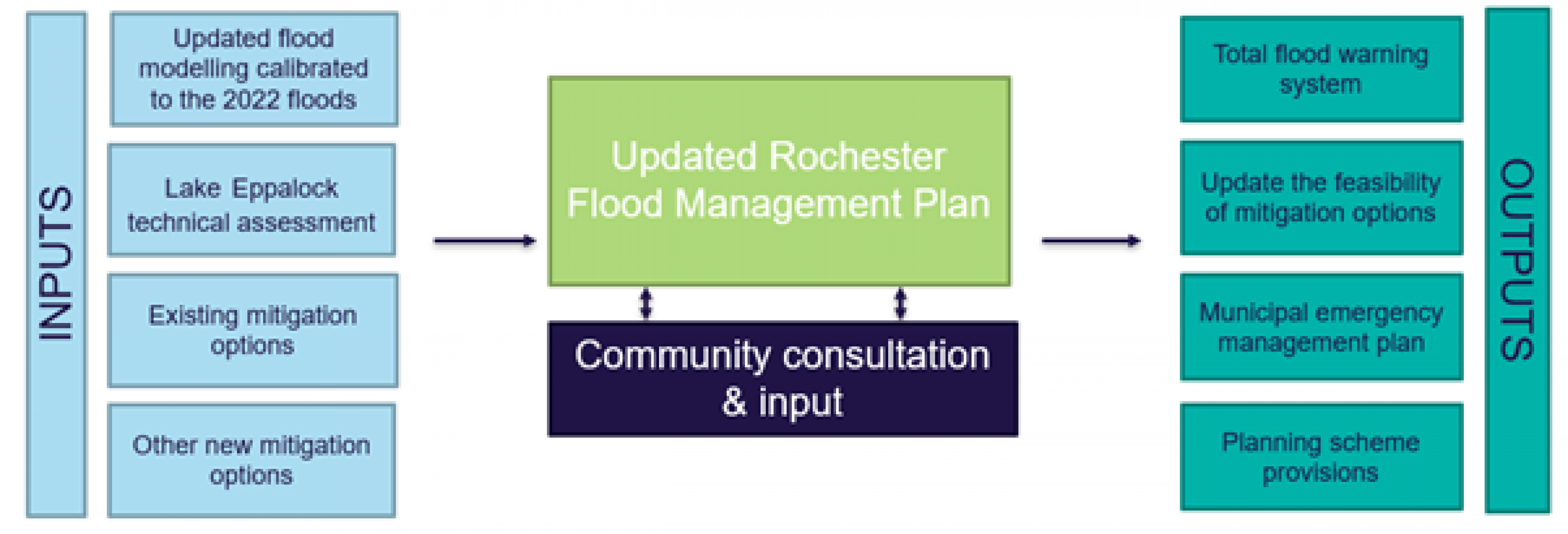
How do the technical assessment and the Rochester Flood Management Plan fit together?
Campaspe Shire Council, with technical support from NCCMA, are reviewing the Rochester Flood Management Plan and updating flood modelling calibrated to the 2022 floods.
The Rochester Flood Management Plan will also update the feasibility of mitigation options already assessed and investigate any new recommendations, including the outputs from the Lake Eppalock technical assessment.
The update of the plan is expected to take approximately 18 months to complete, with community consultation and input an important part throughout. To register for updates on the progress of the Flood Management Plan or if you have photos or other information about flood behaviour which could be used in the development of the plan, please email shire@campaspe.vic.gov.au.
Background
Lake Eppalock is designed and operated to provide a secure and safe water supply. Whilst Lake Eppalock does provide flood mitigation benefits, the ability to mitigate downstream flows so they remain below flood thresholds reduces as the storage becomes fuller and floods become larger.
Lake Eppalock’s full supply level is 193.91 m AHD, at which it holds 304,650 ML. The dam is constructed of earth and rockfill and has 3 fixed crest spillways, each of which begins to spill water at different reservoir levels and has limited pre-release capability (max. approx. 1,800 ML/d).
Prior to January 2011, there had only ever been flows through the primary spillway.
On 14 October 2022, flows over the spillways peaked at 103,000 ML/day; a new historical high.
Inflows at Lake Eppalock peaked at 235,000 ML/day, which means Lake Eppalock more than halved the peak daily flow.
The Goulburn-Murray Water website provides more information on the flood event in October 2022.
Page last updated: 30/10/24