On this page:
Understanding how riparian systems change in response to management and evaluating how they are implemented will improve the efficiency, effectiveness and long-term benefits of riparian management in Victoria.
Riparian works evaluation
In 2011 to 2012, an investigation evaluated a sample of riparian sites in Victoria where on-ground management works had been completed over the last decade.
It determined the condition of riparian works and landholder attitude to the works. For example:
- Where fencing was erected to prevent stock access to riparian land the fencing was still functional at 86% of sites.
- On average, landholders gave 'willing to recommend riparian work to others' a score of 9 out of 10 and most considered they would do more riparian work themselves.
- 76% of landholders indicated that there had been no loss of productivity across the property as a result of the riparian works.
- 74% of landholders indicated that they considered that the condition of the waterway had improved as a result of riparian works.
- Landholders overwhelmingly supported the works and would recommend similar work to other landholders, and some thanked the catchment management authority for a job well done.
Landholder feedback
"I can’t understand why more farmers don’t do it. In the past, we would lose one or 2 animals in the stream each year, but we haven’t lost any for years. Property looks better with healthier streams and surrounds and has increased in value."
Riparian works evaluation project
Riparian Intervention Monitoring Program
The riparian intervention monitoring program is a long-term intervention monitoring program aimed at demonstrating if management activities have improved the health of riparian land.
It is being undertaken on a selection of sites around Victoria by CMAs in conjunction with landholders.
The program uses a robust experimental design that measures ecological responses to riparian management interventions such as fencing, weed management and revegetation.
The program ensures that knowledge gained through the monitoring and evaluation process is used to improve:
- delivery standards that underpin riparian investment decisions
- communication of the riparian management’s benefits delivered through waterway health investments.
Stream change assessment: Riparian woody vegetation using LiDAR
Light Detection and Ranging (LiDAR) can assess riparian vegetation across large areas in Victoria. It was first used for the 2010 Index of Stream Condition (ISC). The ISC provided snapshots of the condition of Victoria’s rivers in 1999, 2004 and 2010.
LiDAR was recaptured at about 13% of the ISC network from 2018 to 2020. This provided a more consistent and comprehensive data collection method to enable comparisons of the 2 data sets.
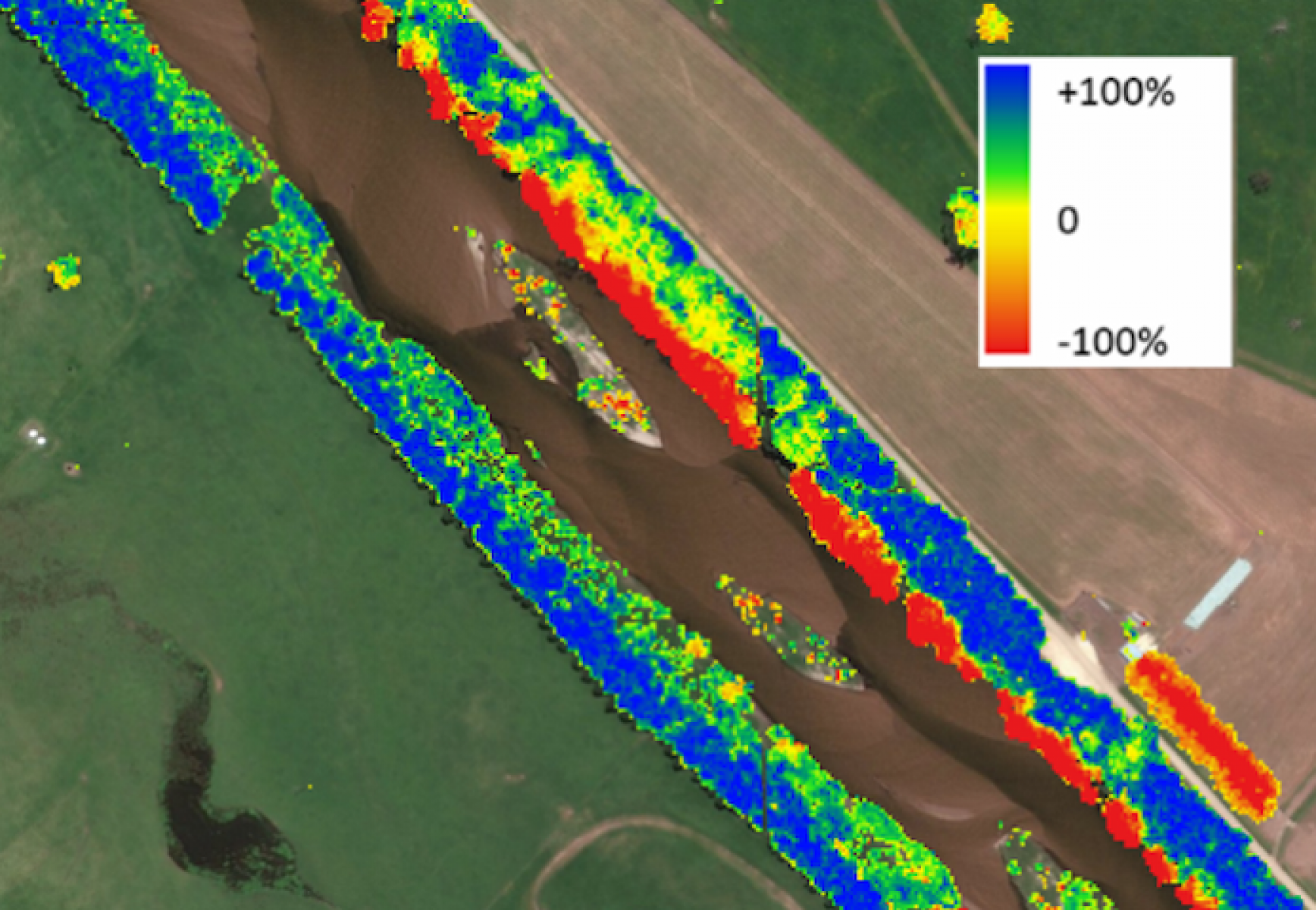
Results
Change in riparian woody vegetation between 2010 and 2020 at the scale of river reaches was generally minor and variable. However substantial improvements were evident along smaller stretches of river where riparian management has occurred.
While some substantial changes at certain reaches were seen, they were generally small at statewide and regional extents. This was not unexpected because:
- Changes in vegetation due to management are likely to occur over longer-time frames than the 8 to 10-year period between assessments.
- Changes in riparian vegetation are likely to vary at a range of spatial scales, so when data are aggregated, increases at some locations are likely to be masked by decreases at others.
- LiDAR was recaptured at reaches for a range of reasons (including some reaches where no or minimal riparian management was undertaken), so results should be viewed within this.
These results will inform our approach to riparian management work in Victoria in the future.
Stream change assessment
Page last updated: 08/09/23