The Latrobe River originates on the Baw Baw Plateau and passes through relatively flat to undulating plains cleared for agriculture, before flowing into Lake Wellington.
The system is used by the community, irrigators and power generators.
Access to water is integral to the Gunaikurnai people for customary practices, protecting cultural values and uses, gaining economic independence and healing Country.
It also supports a series of wetlands, lakes and native environments.
Regional water studies have shown that the annual volume of water in the Latrobe River system has decreased substantially from an average of around 800 gigalitres (GL), since 1975, to approximately 600 GL, since 1997.
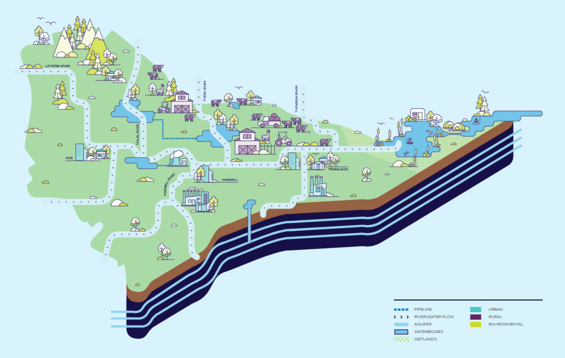
Like surface water, groundwater is a key resource for consumptive use in Latrobe region and an important part of the water cycle.
In Latrobe, mine operators extract groundwater to maintain the stability of the coal mine voids during mining activities.
Aquifers in the Latrobe Valley include the Morwell Formation Aquifer, Traralgon Formation Aquifer, the Haunted Hills Gravel Aquifer.
The Latrobe River has been identified as a working river with high demands from industrial, agricultural and urban areas and adjoining land uses.
Through agriculture, power generation, business and industry, and the environment, the Latrobe River supports the region’s economy and is one of the major tributaries to the internationally significant Gippsland Lakes Ramsar Site.
The Moondarra Reservoir has a capacity of 29.9 GL and is fed primarily by the Tyers River and Jacobs Creek.
Moondarra Reservoir is owned and operated by Gippsland Water to supply their customers, which has previously included Hazelwood Power Station. Gippsland Water transfers water it holds in Blue Rock Reservoir to Moondarra Reservoir via pipeline.
Lake Narracan is an artificial lake built with a capacity of only 7.2 gigalitres.
It was constructed to provide water for power generation for brown coal power stations but now is also used by the community as a popular recreation location. These supplies are supplemented from the much larger Blue Rock Reservoir.
Blue Rock Reservoir (or Blue Rock Lake) has a capacity of 198.3 GL and is fed by the Tanjil River.
Its storage is shared between a number of users, including power generators, Southern Rural Water, Gippsland Water and the Victorian Environmental Water Holder.
Water from Blue Rock Reservoir provides for urban demand, irrigation, environmental entitlements and power generation.
The Morwell River was diverted in 1977 from its original course to a new direction around the Yallourn Power Station.
This involved building a 3km tunnel to carry the river’s baseflow and an additional 3.7km tunnel for floodwaters.
In 2014, the diversion was repaired following a flood burst.
Tanjil River is the primary source of inflows to Blue Rock Reservoir.
Lake Wellington is one of 3 major waterbodies that make up the Gippsland Lakes in the state's far east, the largest navigable inland waterway in Australia.
The lake's ecological character is at risk from a reduction of inflows and rising salinity primarily as a result of a changing climate.
Lakes Entrance is a man-made channel opening that links Bass Strait to the Gippsland Lakes. It is an important location for tourism, recreation and fishing. It also sustains the lake's salinity levels.
Potential sea level rises as the result of climate change could push saltwater further into the estuary and the river system. Larger flows from the Latrobe and Thomson rivers help prevent this.
Most parts of Victoria are experiencing, and will continue to experience, the effects of climate change. Across a series of tested climate scenarios for the Latrobe region, there is a projected median 4.5% reduction in rainfall and 16.7% reduction of runoff into rivers and catchments by 2065.
More severe modelling suggests greater decreases. This means that in the future, existing water users could receive less.
Water uses
Yallourn Power Station has been providing energy to Victoria since 1974 and is the region's largest mine.
The Yallourn Power Station has the legal right to use water from the Latrobe River system for the purpose of power generation, returning some of that water to the system, which benefits the environment and irrigators.
725 GL of water would be required to fill Yallourn Mine if a water-based rehabilitation option that filled the mine was approved.
Together, Loy Yang A and Loy Yang B are Australia’s largest power station.
The Loy Yang power stations have the legal right to use water from the Latrobe River system for the purpose of power generation, returning some of that water to the system, which benefits the environment and irrigators.
1,418 GL of water would be required to fill Loy Yang mine if a water-based rehabilitation option that filled the mine was approved.
For more than 50 years since 1964, Hazelwood Power Station contributed 25% of Victoria’s power requirements.It was decommissioned in 2017.
638 GL of water would be required to fill Hazelwood mine if a water-based rehabilitation option that filled the mine was approved.
A water entitlement is a legal right to take and use water granted under the Water Act 1989.
They provide the right to take or store a volume of water subject to conditions. Bulk and environmental water entitlements are held by specified authorities, such as water corporations and power generators.
In the Latrobe Basin, there are 16 bulk entitlements for surface water.
Alternative water is water from sources other than the Latrobe River system or Latrobe Valley aquifers, such as recycled water, desalinated water or treated stormwater.
Alternative water is currently produced and used in a variety of ways across Victoria and is managed to meet public health, environmental standards and to meet community expectations.
The Gunaikurnai people are the recognised Traditional Owners of much of Gippsland, including the Latrobe Valley.
As of September 2019, it is now a legislative responsibility requiring Traditional Owner water values and uses to be integrated into water planning and management across Victoria.
The Gunaikurnai Land and Waters Aboriginal Corporation (GLaWAC) is the prescribed body corporate on behalf of the Gunaikurnai people.
Agriculture across the Latrobe region is dependent on both surface and groundwater sources.
Irrigators use Section 51 licenses to take and use water from the Latrobe system including some of the water that is returned to the system from power producers.
In 2020, Gippsland Water serviced 36,762 Latrobe residential customers and 3,323 non-residential customers (businesses, schools, parks) for an estimated population of 75,991.
Water for these customers predominantly comes from the Moondarra Reservoir, Blue Rock Reservoir and Narracan Creek.
The Latrobe system supplies the townships of:
Boolarra
Churchill
Cowwarr
Darnum (north side of freeway and Fonterra milk factory)
Erica
Glengarry
Hazelwood North
Moe
Morwell
Rosedale
Thorpdale (carting)
Toongabbie
Trafalgar
Traralgon
Traralgon South
Tyers
Willow Grove
Yallourn North
Yarragon
Yinnar.
There are about 490 farm dams in the Latrobe Basin that are used for irrigation and commercial purposes. Estimated usage will vary from year to year according to climate.
In 2017-18, an estimated 3,924 megalitres of water was used from these farm dams. A commercial or irrigation dam must have a Section 51 license.
Water-based recreational activities include boating, fishing, power boating, water skiing, jet skiing, sail boarding and sailing and hunting as well as hiking and cycling alongside waterbodies.
In some areas like Lake Narracan, there are arrangements in place between councils and water corporations that allow for water levels to be altered for recreation benefits like recreational events.
The Latrobe River system supports a vast tourism industry throughout the Latrobe region, covering accommodation, camping, boating, hiking, wildlife and birdwatching, food and drink, transport and the Gippsland Lakes.
The value of the Gippsland Lakes is estimated at $250 million per year.
Tourism also employs 9,200 people in Gippsland both directly and indirectly.
Commercial fishing in the Gippsland Lakes is heavily licensed and from 2020 has been banned.
This ban is to rebuild fish stocks with an emphasis on recreational fishing. Commercial bait, eel and mussel fishing will not be impacted and will be permitted in the Gippsland Lakes.
Environment
Regional water studies have shown that the annual volume of water in the Latrobe River system has decreased substantially from an average of around 800 gigalitres (GL) since 1975 to approximately 600 GL since 1997.
It also found there are uncertainties associated with climate change and projected water availability, which means all users must plan for a drier future.
Lake Wellington is one of 3 major waterbodies that make up the Gippsland Lakes in the state’s far east.
Lake Wellington alongside Lake Victoria, Lake King and a number of smaller lagoons and wetlands cover an area of 400 km2, forming the largest navigable inland waterway in Australia.
The lake’s character is at risk from a reduction of inflows and rising salinity primarily as a result of a changing climate.
The Gippsland Lakes are internationally recognised by The Ramsar Convention on Wetlands of International Importance for their very significant environmental values.
We have an international obligation to preserve this site for its ecological character and report any changes.
A drying climate and increase in water use threaten the values the Gippsland Lakes were listed for, as well as the significant economic benefits to the region provided by recreation and tourism.
The lakes are an important drought and migratory refuge for waterbirds, regularly holding up to 20,000 ducks, swans, coots and other waterfowl.
Many birds, mammals, amphibians, fish and invertebrates supported by the Gippsland Lakes are rare, vulnerable, endangered or threatened in Victoria, including the recently discovered Burrunan dolphin.
The site also supports indigenous plant species, threatened natural landforms and native wildlife species.
These 2 large wetland systems are located where the Latrobe River and Thomson River meet and flow towards the entrance of Lake Wellington.
Together they cover several thousand hectares and support a range of wildlife. They can become heavily impacted by salinity from Lake Wellington if flows decrease.
The Latrobe River system and fringing wetlands rely on environmental water entitlements, on top of natural flows, to provide for sustainable habitats for many threatened and endangered species.
These species as well as the wider health of the system could be threatened by further loss of flows from the Latrobe River.
The Latrobe River system supports plants, wildlife and ecological communities, many of which are classified as threatened, vulnerable, endangered or critically endangered.
These include the
Australian grayling
green and golden bell frog
growling grass frog
Australasian bitter
fairy tern
dwarf kerrawang
swamp everlasting
metallic sun-orchid
Burrunan dolphin
as well as vulnerable coastal saltmarsh vegetation.
This freshwater fish (nicknamed the cucumber fish or cucumber herring) offers us a great glimpse into the health of the Latrobe River system.
The ability of this threatened fish to complete its life cycle spawning, larvae and juvenile migration, and adult movement demonstrates whether the river’s flows, refuge pools and habitats are healthy.
The upper forested areas of the Latrobe region are home to a range of significant species of wildlife including fish, crayfish, birds and small mammals.
Most parts of Victoria are experiencing, and will continue to experience, the effects of climate change; this includes in rainfall and runoff into rivers and catchments.
This means that in the future, existing water users including the environment, farmers and irrigators, urban customers and power providers/mine operators could receive less.
Lakes Entrance is a man-made channel opening that links Bass Strait to the Gippsland Lakes.
It is an important location for tourism, recreation and fishing.
It also sustains the lake’s salinity levels, which helps maintain populations of birds and wildlife like the endangered Burrunan dolphin.
Mining activities have had a substantial impact on the physical form and geomorphic processes of the Latrobe River system.
The Morwell River Diversion Project started in 1977.
Over time the underground pipes that diverted the Morwell River at Yallourn and Hazelwood have been replaced with aboveground diversions and aqueducts that can better mimic more natural conditions.